
The Role of Satellite observation in the Lebanese Crisis
UNITAR was involved in the recent Middle East crisis through its operational satellite applications programme UNOSAT.
Immediately after the beginning of hostilities, in July 2006, UNOSAT received requests for satellite imagery of the areas of Lebanon affected by the crisis. These requests came from both UN agencies and international NGOs that had previously used UNOSAT services for relief coordination and impact assessment.
Satellite imagery is frequently used to support and organize emergency assistance in case of natural disasters because it produces rapidly information on large territorial surfaces. However, in the case of crises involving conflict situations, earth observation from satellite offers other distinctive advantages such as objectivity, monitoring of locations not accessible to staff due to security problems, and updated information on road networks and their current state.
Helping Humanitarian Relief
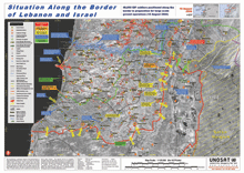
The humanitarian implications of the crisis appeared more serious as the hostilities progressed. The first maps realised using satellite imagery processed at the UNOSAT operational computing centre hosted at CERN were provided to OCHA and other members of the Inter-Agency Standing Committee (IASC) to support the planning of humanitarian relief to populations in Southern Lebanon. UNOSAT mapped incidents and bombings in the region along the border with Israel and produced a detailed map of the entire country based on available public information.
When the Task Force on Lebanon was established and dedicated funding was secured, UNOSAT begun producing more detailed maps and issued daily updates illustrating all the incidents and their exact locations. One UNOSAT staff was on the ground in Lebanon to assist in this work and validate maps produced in Geneva.
Supporting Recovery
Satellite derived mapping plays an important role in post crisis situations because it allows to visualise complex information combining geographic features with socio-economic data and salient facts regarding the crisis. In the case of Lebanon, this included displaced populations, their return process, the presence of large amounts of un exploded ordnance, the state of roads and agricultural sites, damaged buildings and a large oil slick.
In similar situations maps combining diverse layers of data are useful in assessing the actual situation of areas and towns affected by the conflict, which is an invaluable asset when designing recovery strategies in collaboration with the national authorities. Field verification by UNOSAT staff showed a very strong correlation with results inferred from satellite imagery.
Providing information for human rights protection
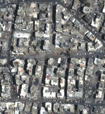
In the case of Lebanon UNOSAT produced also detailed damage assessment maps derived from very high resolution satellite imagery and grouped in atlases for easier reference and use. At this resolution (1 meter) building features become clearly identifiable.
UNOSAT was able to estimate the number of buildings affected by bombardments and identify various degrees of structural damage. Using before-after analysis, images of the same area are compared to infer detailed information.
This information is useful in various contexts ranging from shelter, recovery of urban settlements and even violations of human rights.
Francesco Pisano,
UNITAR/UNOSAT
